Archives
The Cemeteries of St. John’s Lutheran Church
St. John’s Evangelical Lutheran Church was organized in 1857, and nine years later, the congregation established its first cemetery. The burial ground known as Old Lutheran Cemetery was created in 1866, and served the congregation until a new cemetery—St. John’s— was opened in 1874. Another San Antonio congregation, Immanuel Lutheran, opened its cemetery immediately adjoining St. John’s, and when the two congregations merged in about 1903, St. John’s and Immanuel cemeteries were also combined. Though burial records are divided between these two cemeteries, they appear to the visitor as one cemetery.
The existing records of the three cemeteries are housed in St. John’s archives. The records were kept once in an office at St. John’s cemetery and were partially destroyed by fire many years ago. It is thought that the extant records were reconstructed from a variety of sources including old church record books. Work is ongoing to update cemetery records by cross-checking against other sources.
While the records are a valuable research tool, many burials, both marked and unmarked, are missing. Families with proof of a burial not included in the records are asked to share this information and proofs with the church archives in order that we might make our database more complete.
Old Lutheran Cemetery
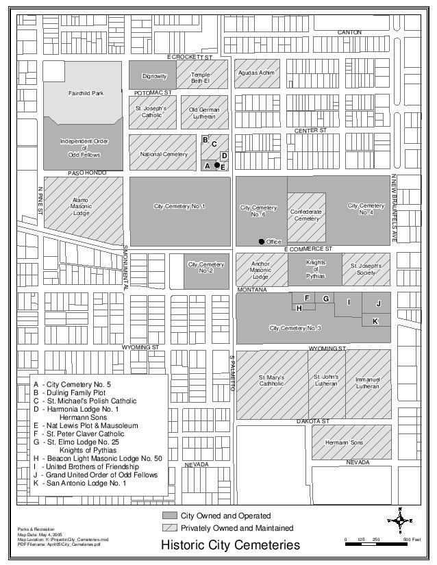
Old Lutheran Cemetery is located north of Commerce Street at the northwest corner of Center and Palmetto Streets. It is bounded by Potomac Street on the north, Center Street on the south, Palmetto Street on the east, and a grassy easement on the west. The cemetery is entered from Center Street. For reference, the cemetery is immediately north of the Old San Antonio National cemetery, south of Temple Beth El cemetery, and east of St. Joseph’s Catholic cemetery.
The oldest marked burial is that of Gustav Rader dated October 14, 1866. This database originated with the archival records of Old Lutheran cemetery and was updated in 2004-05 by two Eagle Scout candidates, Zachary Dean and Geoffrey Robinson. Dean assumed the additional task of inventorying the rows now designated “Southeast” (SER) and “Northeast” (NER) and compiling an updated map of the cemetery. Lot numbers on the map correspond to the archival records with the exception of burials in the Southeast and Northeast rows.
Gravestone inscriptions were also transcribed by Zachary Dean and Geoffrey Robinson. Those will be added to this database at a later time.
St. John’s Lutheran Cemetery (“New Lutheran”) and Immanuel Lutheran Cemetery
St. John’s/Immanuel Lutheran cemeteries are located south of Commerce Street. They are bounded by Wyoming Street on the north, Dakota Street on the south, New Braunfels Avenue on the east and St. Anthony Street (abandoned) on the west. The cemeteries are entered from Dakota Street. For reference, the cemeteries are located immediately north of Hermann Sons cemetery, south of City Cemetery #3 and the African American Lodge cemeteries, and east of St. Mary’s Catholic cemetery.
These databases represent the archival records of the two cemeteries. While they are valuable research tools, they have not been cross-checked against gravestones or other church records.

